Mt.
Columbia
Colorado 14er
14,073 feet, 4289 meter
Colorado 14er
14,073 feet, 4289 meter
|
|
Mt.
Columbia
Colorado 14er 14,073 feet, 4289 meter |
|||||||
|
||||||||
|
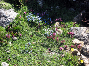
Harvard is the 3rd highest peak in Colorado and stands at the end of the Basin. I really like this climb. It has everything you would expect in a Colorado 14er - snowcapped mountains, great views, wildflowers, marmots and a nice rocky route to the summit. This is one of my favorite climbs. On the other hand, Columbia, 35th highest, stands guard on the eastern side of the Basin. It looks high. Her sides are covered with scree, small pebble sized rocks, that provide as much traction as ice underfoot. The best thing I can say about Columbia is that it hides the morning sun on a hot day. We made the summit of Harvard around 8:00AM and took about an hour enjoying the views and contemplating the route via the ridge to Columbia. We had researched it via other trip reports so we knew we would not take the ridge proper since it was a class 5 route and could require ropes and protection. So we left Harvard's summit looking for any marked path but not expecting much. To my surprise, there was a well worn path leading down towards the ridge. For the next hour we simply followed the path enjoying the views and an incredible collection of wildflowers. It was amazing to see so much life at 14,000'. But just as I was thinking this was too easy to be true, we lost the
trail. Somewhere around 13,500 high up on the ridge. We knew that the
fastest route was to drop down into Frenchman Creek Drainage but I wanted
to stay higher on the ridge. Patrick mumbled that we should go lower.
He quoted several reports saying to descend to 12,600'. But I was seduced
by the ridge and kept going. Soon, with Robert in support, Patrick headed
down towards the basin. The bad news was that it down a steep boulder
field. We descended slowly but steadily until we actually touched the
grass in the Drainage and then turned towards Columbia. At this point
I pointed out that we should have descended earlier. Patrick just shook
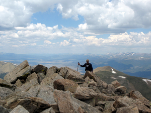
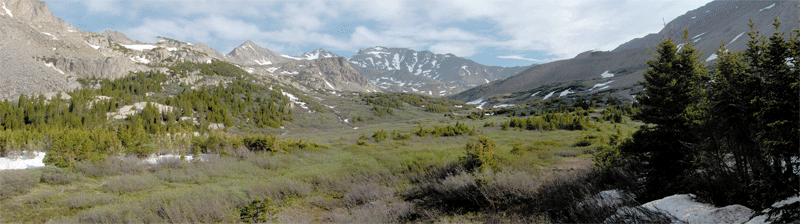
his head!  The view from the drainage was both exhilaratingly and concerning. The ridge connecting Columbia and Harvard was in full view as was the route we took down from Harvard. We could also spot the scree and grass slopes headed to Columbia's summit. We knew we had to climb back up almost 1600' to gain the summit of Columbia. So, without a lot of discussion we headed towards our goal stopping occasionally to eat something or watch the bighorn sheep grazing on this high altitude mesa. The route was not obvious but Patrick had the GPS coordinates for Columbia so we headed towards the sumit even though it was not in view for most of the time. Of course, the ridge provided the general direction but which route reamined a mystery. Taking the most direct line up we found ourselves scrambling over the boulders guarding Columbia's summit. Three hours after leaving Harvard, we stood on top of Columbia. The view of Buena Vista was great as was the surrounding Sawatch Range. The clouds were starting to form and sleet began to pelt us as we left the summit. We hiked a mile down Columbia's gently summit slope until a well placed
carin and red cloth marked the cutoff down the scree slopes. For the
next hour we descended over 2,000'. The route was clear but miserable.
When the scree was missing it was replaced with loose soil that gave
way under the slightest pressure. At this point we had been on foot for
over ten hours. We were tired. 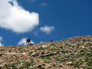 This was my sixth climb of a 14er this year. It was a great work-out but also a nice experience with my friends. Harvard remains a great climb while Columbia, well, I am glad that is checked off my list. The scree was bothersome and the never ending climb to the summit annoying. But that is why we do it! Well, that is not exactly why but it is for the sense of accomplishment of climbing two 14ers by putting in over 16 miles and gaining over 6200' in elevation. |
|
 I saw Mt. Columbia during a climb of Mt.
Harvard in June 2005. The connecting ridge looked "interesting" and
I told myself I would return one day to bag Columbia via the traverse.
So on July 14, 2007 I met my regular partners, Patrick and Robert, at
the North Cottonwood Creek trailhead at 9,880 feet. We tent camped and
left for Mt. Harvard at 4:15AM on Sunday morning.
I saw Mt. Columbia during a climb of Mt.
Harvard in June 2005. The connecting ridge looked "interesting" and
I told myself I would return one day to bag Columbia via the traverse.
So on July 14, 2007 I met my regular partners, Patrick and Robert, at
the North Cottonwood Creek trailhead at 9,880 feet. We tent camped and
left for Mt. Harvard at 4:15AM on Sunday morning.