|
Gerry Roach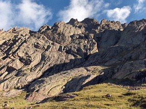 says in his Colorado's
Fourteens Bible that Crestone Peak "... is one of Colorado's hardest
--some people proclaim it the hardest." Well I have not climbed
them all but it certainly ranks up there in my experience. It was
an extremely long and physical day. Patrick and I intended on tagging
the Peak then traversing over to the Needle for a double bagger on
Sunday, August 21, 2005. says in his Colorado's
Fourteens Bible that Crestone Peak "... is one of Colorado's hardest
--some people proclaim it the hardest." Well I have not climbed
them all but it certainly ranks up there in my experience. It was
an extremely long and physical day. Patrick and I intended on tagging
the Peak then traversing over to the Needle for a double bagger on
Sunday, August 21, 2005.
I picked Patrick up at his home on Saturday in a drenching downpour
that had city storm drains maxed out and two inches of hail on
the ground. Undaunted, we made the final drive to Silver Cliff
then turned south on highway 69, found Colfax Lane and eventually,
at the end of the last smooth road for two days, a parking lot
full of otherwise good cars and trucks. We planned on camping
at the South Colony Lakes that night. We took my Jeep Wrangler
on this trip since we knew the infamous "worst 4WD road in Colorado" would
test our city vehicles yet save us 5.7 miles of humping our backpacks
to the lake. The reputation of this "road" is alive and well.
I'll get to the climbing in a moment but this road. Ah, this
road. It is not a road. A road has lanes. It has sides. It has
lines. It allows a vehicle to move faster than a person can walk.
That is a road. But noooo, this road has trees with overhanging
branches for sides. It has small, medium, large and ridiculous
rocks laid out in a random pattern that would have frustrated
Gallelo. It has rushing streams that looked like car washes.
It had bottomless puddles. It had Pamela Anderson sized banks
which tilted the Jeep at 45 degree angles. Oh, did I say it had
rocks? See the video.
It took us 1.5 hours to go 5.7 miles. A turtle passed us.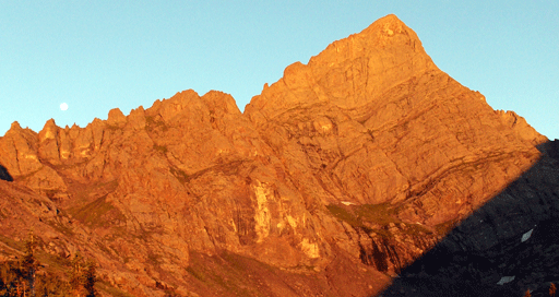
Kissing the ground like Pope Paul, we staggered out of the jeep
at 11,000'. We had arrived later than we had planned but the
sight of Humboldt was impressive looking to our south in the
late day sun. We had hoped all the heavy weather had stayed north
but clouds were forming a thick layer over the Needle so we picked
up our pace on the 1.5 mile hike to South Colony Lakes at 11,660'
for the night. Just as we arrived, it was "Hell Storm" part Dux.
If it had not been for another party camping nearby with a tarp,
I would be an inch shorter and severely bruised from the golf
ball size hail that pummeled us. We decided to take advantage
of our new friend's tarp to cook dinner while we watched the
hail switch to rain and next anticipated seeing locusts start
falling from the sky.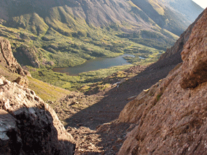
Finally we got our tents pitched as the weather calmed and soon
we were in our bags hoping to get a few naps before the early
morning call. The night passed uneventful as we awoke to a clear
and chilly morning. We loaded small day packs with food, water
and an extra layer and began the gentle climb to Brokenhand Pass
at 12,900'. It was easy class 2 on a well worn trail marked with
six foot cairns. The crux of this section was the top of the
400' couloir which required some easy class 3 moves to reach
to top of the pass. Our work was rewarded with great views of
Colony Lakes to the east and Cottonwood Lake to the west. And
of course there was Crestone Needle proudly strutting herself
to our north. The only thing ruining the view was the fact we
had to descend 800' to begin the climb of the Peak!
  We
spotted the "correct" couloir to descend the Needle and We
spotted the "correct" couloir to descend the Needle and
began
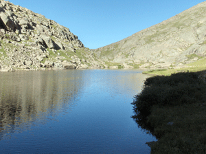
the easy descent to Cottonwood Lake. Soon we could see the Peak
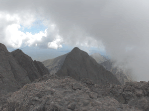
for the first time. The summit played hide and seek in the clouds
2100' above us. It was in the middle of the high ridge that started
at the Needle and gently sloped westward down from the Peak.
The Cottonwood Lake area was pristine, secluded and quiet on
the Sunday morning. A few other climbers were in the area but
it was the marmots and birds that provided the entertainment.
As we took a break to put on helmets, gobble some Cliff Bars
and take a long drink, we sighted the "red couloir" that would
serve as our route to the summit. It was easy to see given the
reddish color as was the stream of water pouring through the
center! It had take two hours to reach this point and we were
starting to get concerned about the swirling clouds that were
forming now around the traverse and the Needle. We knew we would
not attempt it if the visibility was poor given the notoriously
difficult route hidden below the ridge skyline.
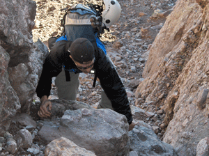
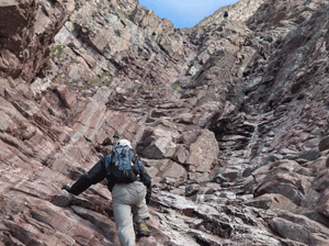
 The route
from the west end of Cottonwood Lake's tundra makes a lazy reverse
C sweep around an outcropping to a grassy ramp at the base of
the couloir. The goal is a notch, called the Red Saddle, in the
ridge at the top of the couloir, 700' directly above our heads.
While the climbing is not difficult it is tedious and long. There
are a few short sections of hands and feet climbing but nothing
too hard. After a while we attained the ridge and made the final,
surprisingly simple, 250' to the summit. A four hour one way
trip. The route
from the west end of Cottonwood Lake's tundra makes a lazy reverse
C sweep around an outcropping to a grassy ramp at the base of
the couloir. The goal is a notch, called the Red Saddle, in the
ridge at the top of the couloir, 700' directly above our heads.
While the climbing is not difficult it is tedious and long. There
are a few short sections of hands and feet climbing but nothing
too hard. After a while we attained the ridge and made the final,
surprisingly simple, 250' to the summit. A four hour one way
trip.
Once on top of the summit, we watched as cloud moved over us
and obscured the views in every direction. These were not storm
clouds per se but condensation created by the sun on the damp
rocks. Crestone Peak has one of the smallest summit area I had
seen. But we had it all to ourselves for a while until a lone
climber joined us. We discussed the traverse and decided against
it. First was the poor visibility, second it was 10:30 and that
would put us on the Needle after noon (should have started earlier)
and third, the 2000' climb up the red couloir was tougher than
we thought. So, another day!
With that out out the way, we enjoyed the summit for forty-five
minutes took a few pictures and videos.
The down-climb of the couloir was as tedious as the up-climb
and not a lot faster. But it was the sight of Brokenhand pass
that kept our attention. We soon climbed back over the pass and
back down to our tents near Colony Lakes arriving around 3:00.
As we broke camp, we laughed that the easy section was over and
the only thing between us and a greasy burger in Silver Cliff
was 5.7 miles of "road"
So, is Crestone "the hardest" 14er out there? I don't
think so. It is a long day that will tax you physically. The
route finding is straightforward. The red couloir is long but
manageable. I actually think the Trough on Longs is more bothersome
with it's constant loose scree. It was disappointing not to have
made the traverse if only for knowing we will have to take that
road again! But as always in climbing you use your best judgement
so no regrets.
|