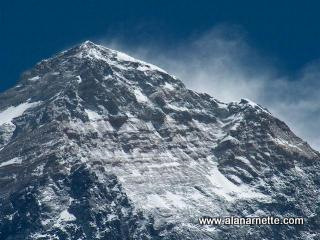
Mt. Everest Southeast Ridge
aka South Col
Himalaya - Nepal
29,031.69-feet or 8848.86-meter
|
|
Mt. Everest Southeast Ridge aka South Col |
||||||||||
|
|||||||||||
| I summited Everest on May 21, 2011 and have climbed it three other times (all from Nepal) - 2002, 2003 and 2008 each time reaching just below the Balcony around 27,500' (8400 meters) before health, weather or my own judgment caused me to turn back. I attempted Lhotse twice - 2015 and 2016. When not climbing, I cover the Everest season from my home in Colorado as I did for the 2004, 2005, 2006, 2007, 2009, 2010, 2012, 2013, 2014, 2015, 2016 , 2017, 2018, 2019, a virtual 2020 season, 2021, 2022, 2023, 2024 , 2025 and now the 2026 season.
This page details the South Col route from Nepal. All the pictures are from my Everest climbs. I have marked the camps and routes we used in all my climbs. Also see the Northeast Ridge route map. "one of the world's most respected chronicler of Everest" - Outside MagazineFollow Alan Arnette's Everest 2025 Coverage |
||
Everest Southeast Ridgeaka South ColClick this link to see large map These images are protected by copyright. Please read this for use information. |
Elevations and Times Between Camps
|
Typical Climb Schedule
|
Base Camp up the Ice Fallclick to enlarge map |
OverviewMt. Everest was first summited by Sherpa Tenzing Norgay and New Zealander Edmund Hillary with a British expedition in 1953. They took the South Col route which is described on this page. At that time the route had only been attempted twice by Swiss teams in the spring and autumn of 1952. They reached 8500m well above the South Col. Of note, Norgay was with the Swiss thus giving him the experience he used on the British expedition. The Swiss returned in 1956 to make the second summit of Everest. Today, hundreds of climbers from around the world use this route to try to stand on top of the world. It is considered slightly more dangerous than the North Ridge Route due primarily to the instability of the Khumbu Icefall. However some considered it slightly easier than the north due to the absence of the ladders and rock climbing on the steep steps of the North Ridge route. Nepal was closed to foreigners until 1950. Recent Events The 2025 Everest expedition has come to a close, marked by strong winds, drones, challenging climbing, and innovative strategies. Along the way were reports of frostbite and helicopter evacuations, but many of these incidents went unreported. Yet, as always, the mountain reminded us that respect is never optional at 8,848 meters. The Numbers According to the December 2025 update from the Himalayan Database, 851 climbers reached the summit in the spring season, 731 from the Nepalese side and 120 from the Tibetan side, representing the third busiest season on record after the 877 summits achieved in 2019. On the Nepal side, 303 members were supported by 428 Sherpas, a strong 1.4:1 Sherpa-to-member ratio, suggesting that more support is required for increasingly inexperienced clients. The Tibet route saw smaller, steadier teams: 68 members and 65 Sherpas, or a support ratio of roughly 0.76:1, consistent with its more experienced approach. Across both routes, 766 men (56% success) and 85 women (76% success) reached the top, extending a positive trend in women's participation and completion rates. Almost every climber used supplemental oxygen, all but four, underscoring how central oxygen management remains to Himalayan logistics. Route Performance On the south side, 63% of member with permits (303 of 481) ended in success. The north posted a much higher rate of 86% (68 of 79). Alpenglow noted
Losses and Lessons Tragically, five climbers died this season, all on the Nepal side, setting the fatality rate at roughly 0.27%. That’s among the lowest on record, but each number tells a story of risk — a reminder of Everest’s tiny margin for error. Even with modern communications, higher flow oxygen systems, and sophisticated forecasts, the mountain still demands discipline and humility. Rescues The well-respected Global Rescue evacuation operation noted a dramatic increase in rescues again suggesting inexperienced clients or unprepared operators.
Record Summits There were milestones worth celebrating: The gender gap continued to close, as several of the year's most focused and disciplined climbs came from women. The 2025 season reflected many current trends:
Everest in Context Viewed against historical data, Everest has grown markedly safer even as traffic has increased. Between 1923 and 1999, there were 1,170 summits and 170 deaths, a 14.5% fatality rate. From 2000 to 2025, climbers achieved 12,567 summits with 169 deaths, dropping the rate to 1.4%. Still, several years stand out for massive death numbers, 2014, 2015, 2019, and 2023, then mostly natural disasters like serac falls, earthquakes, and avalanches pushed totals sharply upward. Notably, 39% of Everest member fatalities on the Nepal side, 82 of 208, have occurred during descents from the summit, when climbers are exhausted. Death rates across all the world's high mountains continue to decrease primarily due to larger Sherpa support ratios, more reliable oxygen at flow rates up to 8 lpm, improved gear, accurate forecasting, and a shift toward professional guiding on established routes. While among all 8,000-meter peaks, Everest holds the highest absolute number of deaths (339), it has a relatively low death rate of 1.07%. However the historical leaders with high death counts, while reduced, remain high as shown by Annapurna I with roughly 75 recorded deaths and around 510 summits, the fatality to summit ratio is about 15% and the infamous K2 has reduced from 25% to today's 12% primarily due to Nepalese Sherpa companies commercializing the climbs with strong support, standard routes, high oxygen flows and repeatable logistics. Cho Oyu continues to be the safest 8000er at 0.53%, followed by Lhotse at 0.62%. 2026 Preview: A New Era of Costs and Choices The Nepali government confirmed a permit fee increase to $15,000 per foreign climber effective September 1, 2025, up from the longtime $11,000 rate. Combined with insurance, logistics, and agency fees, this could raise average expedition costs by $5,000 to $7,000 per person, bringing a Sherpa-led expedition on the Nepal side to a median price close to $60,000, and for a Western-led climb, now $100,000 or more. While China has not increased its permit fees, in my opinion, look for operators to normalize prices for parity on both sides, thus increasing their profit margins. With Nepal prices increasing, as is the crowding and negative publicity around long queues near the summit, look for 2026 to be a test season to see if climbers will move en masse to the less crowded, albeit more technically demanding Tibetan side. In any event, as of December 2025, operators are putting out "last call" for their 2026 Everest expeditions as they fill up quickly.
Continue reading about Everest 2025 Everest StatsSummits - updated December 2025 Early Attempts and Summits
Male Summits
Female Summits
Summit Statistics
Death Statistics
Latest: Spring 2025
courtesy of the Himalayan Database and my own research. |
|
Khumbu Ice Fall to C1click to enlarge map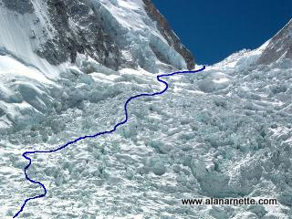
Narrative
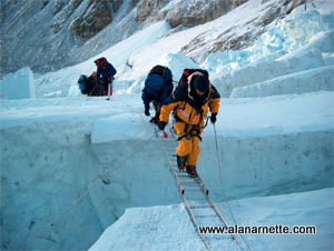
It is common to hear a loud crash, an avalanche in the Icefall or maybe one of those towering seracs falling. Instinctively climbers lower their shoulders and raise their arms over their head. More than likely it was off their route since the Icefall Doctors are careful to avoid the sections of the Icefall where most of these crashes happen or are exposed to Everest's West shoulder's hanging seracs. It should be sunrise but climbers are on the West side of the Icefall and the sun does not hit this are until 9:00 at the earliest. It can be cold if the wind is blowing so most people throw on a down parka during the break. More of the same for another two or three hours. Sherpas returning from the previous day, or even that same morning, of load carrying to the High Camps occupy the route. They had loads that made climbers feel like a wimp. Climbers struggle with their 20lb load and Sherpas scoot by them with their 60 to 100 pound loads. Respect for these special people grow not because of their strength but because of their completeness. At the top of the Icefall, the terrain becomes a flat expanse of snow that leads into the Western Cwm. Camp 1 is still another half to full hour from here. |
Western Cwm between C1 and C2click to enlarge map
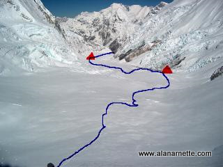
Narrative Once climbers top the Icefall there is a large flat expanse of snow on the western end of the Western Cwm. It looks easy but they are tired. Camp 1 is not visible from the top of the Icefall.
The walk to C1 has a gradual gain but climbers will still be breathing hard. Anywhere from half to a full hour later, the sight of yellow, red or green tents on the pure white snow come into view. But also a large part of the Cwm unfolds in front of climbers. While not all of it is visible, climbers can see Nuptse on their right, Lhotse ahead and Everest on their left. Most climbers don't notice all this since they are focused on getting into their tents and having a brew and some food. Normally each tent prepares their own food at this camp so it starts to feel like a real climb at last. IMG had a large cooking tent where we all gathered and Sherpas boiled water for us.
The sun reflects off the walls of Everest, Lhotse and Nuptse's snow covered slopes making the temperature rise above 100F degrees. Then it can be brutally cold if the cloud moves in, the wind picks up and it starts snowing. Layers are important for this section. Camp 2 seems like a mirage throughout the walk, never getting closer. The last half hour is the most mentally challenging. The route goes up in angle and once in Camp 2 proper, it can be the steepest walk because the tents are set up along a rising rock gully. If your the camp is at the top of the gully, it can be a very long final half hour. |
|
Lhotse Face to C3click to enlarge map
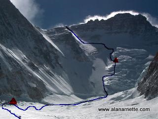
Route from Camp 2 (lower left triangle) to Camp 3 (upper triangle) up the Lhotse Face, across the yellow band and up the Geneva Spur to the South Col. Climbers must be clipped into the fixed line at all times to avoid falling resulting in injury or death. 3-6 hours, 1.64 miles one way The next stage is the Lhotse Face, Lhotse is the fourth highest peak in the world at 27,920 feet. The face is a steep wall of hard packed ice and snow that holds Camp 3. Climbers climb the Lhotse face twice during the attempt on the summit. First as an acclimatization climb and then on the way to the summit. 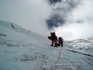
It is not uncommon for someone to die on the Face. The steep angle and hard ice make it difficult to get a grip with their crampons. Climbers must be clipped into the fixed line at all times - even while at Camp 3.
Narrative Each rope is about 200' long so climbers must unclip their carabineers and jumars at the junctions. This is a two step process so that the climber is always attached to the fixed line by at least one device. It is very normal for a long line of climbers to be going up and another long line coming down - usually Sherpas returning from carrying loads to the higher camps. So, in the middle of the Himalayas, climbers have a traffic jam! The angle can be very steep especially just above the base or the bergschrund and again near the top most camps. By steep, I mean 40 to 50 degrees. This can be extremely tiring. There are usually two or three levels of camps because flat areas are at a premium and Sherpas need a somewhat flat area to carve out tent platforms. In 2011, there were three "Camp 3's" ranging from 23,500 to 24,000'. |
Yellow Band and Geneva Spur to C4click to enlarge map
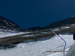
Route from Camp 3 to the South Col. Across the Yellow Band and to the left up the Geneva Spur. This is the first time most climbers start to use bottled oxygen. The climbing and Yellow Band is not technically hard but climbers are approaching 8000m. 3-6 hours, 0.8 miles one way From Camp 3, on the way to the summit, climbers must cross the yellow band and the Geneva Spur on the way to the South Col. These barriers, while not technically difficult, are a challenge at an altitude of 25,000 feet and 6 weeks of expedition life. The South Col is another world. Sitting between Everest and Lhotse at 26,300 feet, it serves as the base for the summit attempt. Climbers don't spend long here since the weather is always temporary and the altitude destructive. Normally it is 8 to 12 hours depending how long the climb from Camp 3 took. Once there, they eat and rest and then go to the summit. Narrative
It can be extremely cold before the sun moves over Lhotse or if the winds are the least bit strong, it can be miserable. But as soon as the sun hits, and there are no clouds, then it can become horribly hot. Many climbers are in their full down suits trying to minimize the weight in their packs. After about a couple of hours they approach the Yellow Band,a strip of limestone that cuts through the Himalayas in this area. They leave snow and climb on smooth rocks at a 20 to 30 degree angle. This is only for about 100 - 300 feet depending on the route that year but it takes concentration. The fixed ropes are a huge asset here. A jam usually occurs in this area if several teams are going for the summit on the same day. Once clear of the Band, it somewhat flattens out until the bottom of the ridge Climbers are a little weary at this point more from the altitude than anything else so when they see Geneva Spur's 150' of 40 degree rock, ice and snow, it causes a long pause. But it is actually easier than it looks. From all the traffic, there are steps but also the uneven rock allows for good foot placement. In low snow years, this area may be snow free and most Sherpas and some climbers remove their crampons to make it easier. Topping the ridge, climbers follow a rocky "path" worn by other climbers and soon step on the South Col proper - an area the size of two football fields with ten or twenty or thirty tents huddled together on the west end. But most climber notice the tents second - after they see the actual summit pyramid of Mount Everest for the first time. |
|
South Col to the Balconyclick to enlarge map
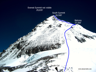
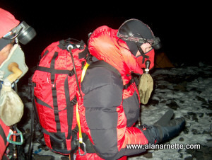
Narrative As we got ready to leave for the summit, they checked our crampons for tightness, that our harnesses were doubled-backed and that our oxygen was set properly with the regulators. They helped us on with packs and then led the climb to the summit. It was obviously dark at 9:20 PM when we set out. Headlamps lighting up the way. Each climber was with their Personal Sherpa. Also each Sherpa and many climbers had a radio each. The climb from the South Col is some of the steepest, sustained climbing on a South Col route climb until you reach the slabs discussed next. In low snow years, the crampon on rock movement creates slips that robs energy. On good snow years, there is usually a well-worn path developed on the route. The fixed line becomes a bit cumbersome and requires careful manipulation of their carabineer and jumar in heavy gloves at each anchor. It is critical to have a solid glove system to maintain dexterity and warmth. The climb through the Triangular Face to the Balcony is long and cold in the dark. Usually there is at least a partial moon in mid to late May so climbers can see the surrounding ground plus the nearby mountains including Makalu and Lhotse. The route seems to go up forever and climbers think climbers are never going to get to the Balcony. Climbers worry that their oxygen may run out as climbers get stuck in a line or are going slowly. But after a few hours, or more, climbers suddenly see the headlamps in front of climbers standing still, if this is not the flat area below the Balcony, it is the Balcony itself and climbers are about there! This is where almost every climber swaps oxygen bottles for a fresh one and also time for a food and water break. See more pictures of the South Col and above
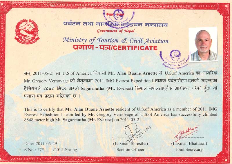
I summited Mt. Everest at 5:00AM on May 21, 2011 with Kami Sherpa of International Mountain Guides (IMG). This video was taken by Panaru Sherpa who climbed with Karim Mella, the first Dominican to summit Everest. The audio at 56 seconds in the video is my dispatch from the summit to this website dedicating the summit to all mom's with Alzheimer's. My mom, Ida, and two of my aunts, died from Alzheimer's.
|
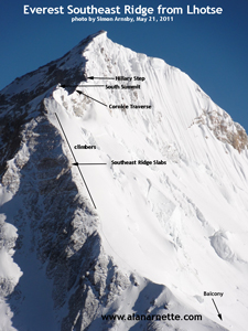
Southeast Ridge to the Summitclick to enlarge all these images
The picture on the right was taken by teammate Simon Arnsby as he summited Lhotse the same morning I summited Everest, May 21, 2011. Click to enlarge it and you can easily see climbers along the slabs. Climbers leave the Balcony on a somewhat gentle grade but it quickly increases to 30 degrees but still on a snow packed boot path in high traffic years. However, this changes when climbers hit the slabs, a long section of smooth to jumbled rock, perhaps 200' in total. The slabs vary in difficulty from annoying to very steep and hard. There are a few sections of 20' to 30' high "cliff like" features of 60 degrees, very steep, where climbers are placing their crampon front points on jutting rock and pulling yourself up with their jumar. This can be exhausting. Also this section can create long bottlenecks both going up and descending. Above the slabs, it gets even steeper, maybe 60 degrees; hard to believe when climbers are there. But this section is short, maybe 100' and on a wide snow slope. The South Summit is the first time climbers can clearly see the final route to the true summit and probably the first time climbers think they will actually summit. The route was a shock to me in that it was still very steep and seemed much more than 500' gain. Once on top of the South Summit, climbers must down climb about 50'. I arm wrapped this section but here was when the winds picked up to over 30 mph coming due west. It became extremely cold and stayed that way until I returned to the South Summit on the descent. It is critical to have goggles and mittens in these conditions After descending from the South Summit, climbers encounter a small rock climb, maybe 10 feet that I mistook for the Hillary Step for a moment. Next is a knife-edge ridge, the Cornice-Traverse leads to the Hillary Step. This is the most exposed section of a Southeast Ridge climb. On one side it is 8,000 ft down the southwest face and on the other, the Kangshung face, a 11,000 ft drop. Some climbers report various degrees of vertigo and being uneasy with soft edges on the boot tracks. I did not find it difficult or frightening since I crossed it in the dark and didn't remember it on the descent. Climbers continue gaining altitude over some rolling bumps and soon see the Hillary Step. The picture below was taken by Brad Jackson in 2009. It is a bit of a shock in that it is relatively high, about 50' of jutting rock. Basically climbers climb the crack. I watched my Personal Sherpa, Kami, climb it and followed his lead There were new and old fixed ropes but not the spider web I had heard about from old ropes. 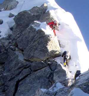
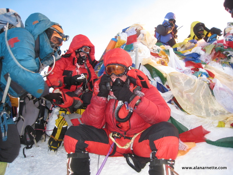
I clipped my jumar and carabineer onto the new ropes and placed my right foot on a small rock ledge, then my left - a classic stem stance. I repeated basically the same moves to the top pulling on the ropes using my jumar. I found it challenging but not nearly as hard as advertised! At the top of the Hillary Step a large boulder aka chockstone sitting on a ledge, blocked the route. You can see it in the picture above the top climber with the rope ascending above it. I stayed clipped in and scooted around it given the thousand foot drop-off to the left and the vertical rock wall to the right. Again, not difficult but somewhat challenging given the circumstances. The final section was another surprise for me. I had expected a long snow slope with the summit visible from just above the Hillary Step but there were more small hills, really bumps that blocked the view and continued to demand a physical effort on top of the altitude requirements. On the right were large snow cornices with interesting shapes created by the prevailing winds. It only took about 20 minutes to go from the Step to the first view of the summit, prayer flags marking the top of the world. 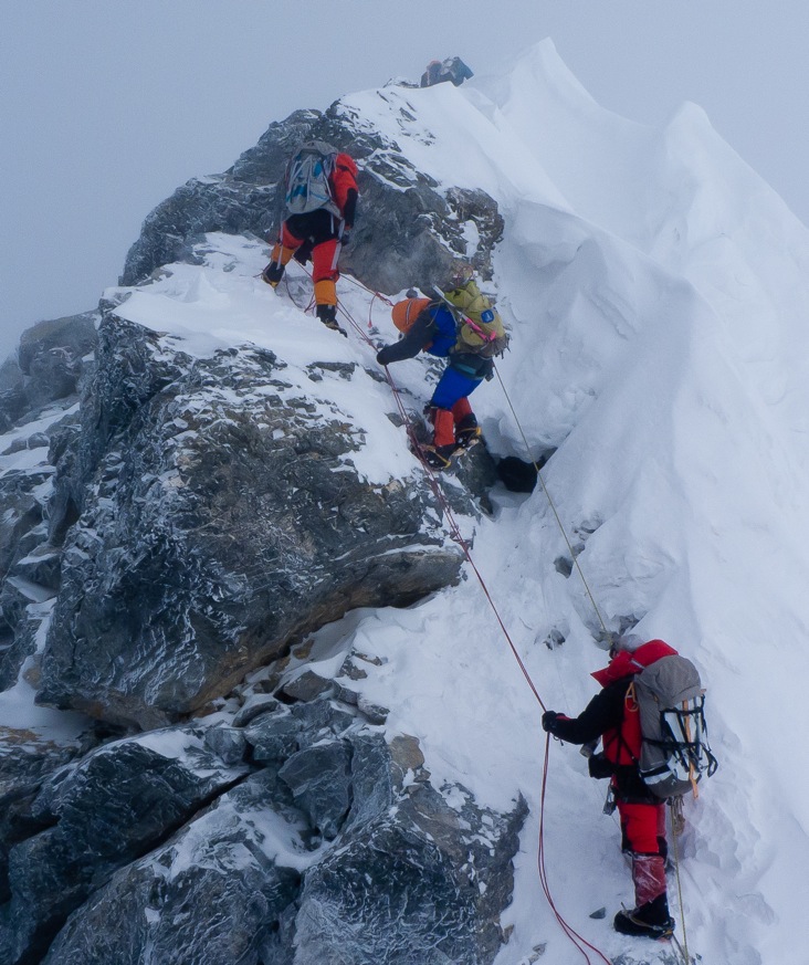
The summit is not big, maybe 30 square feet. It had a small bench carved out of the snow for climbers to pose for pictures. On the other side was the route from the north side, Tibet. Once on the summit, the return climb can be dangerous and has the highest incident rate due to climber's letting their guard down, fatigue or weather conditions that developed during the day. I took a little over 3 hours to return to the South Col, finding it fast with few delays other than at the slabs below the South Summit. I arm wrapped the steep sections. Most climbers will take 9 to 18 hours for the round trip climb from the South Col. My total time was 11 hours as follows:
That's about it. Incredible journey to a unique place. Deserving of every harsh word ever written or said. AND deserving of all the mystique and attraction. |
|
For deep insight into an Everest expedition, download
|
||
|
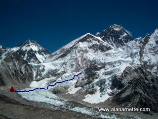
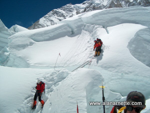 They eat as much as they can at the early breakfast, top off water bottles (not hydration packs since they freeze) and put harness on then start heading towards the icefall. Depending on where their camp is located at Everest Base Camp, this can take 10 to 30 minutes to reach the last flat section, Crampon Point, where they attach their crampons to their boots.
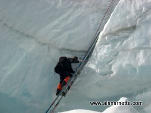
 Next climbers reach a flat section known as the football field. A large area of flat hard packed snow. This is where they take a break, drink some water, slow their breathing and eat something. This is about halfway up and it has taken at least two hours, probably three the first time up.
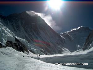 Atop the Ice Fall is Camp 1 serving as a weigh station to the Western Cwm and Camp 2. The Cwm is a 'U' shaped valley carved out by the Khumbu glacier. Everest is on the North (left), Lhotse is directly ahead and Nuptse is on the right or South. The Cwm is straightforward but has several dangers. First it is hot. Temperatures can easily reach 100 degrees Fahrenheit. The sun is reflected by the snow and ice covered walls of the valley and lightly filtered at this 22,000 foot altitude. Then there are the crevasses. Some are crossed on ladders but others remain hidden by thin snow bridges. It was on one of these bridges that I fell into a deep crevasse in 2002. Camp 2 sits on the most Eastern point of Cwm and serves as Advanced Base Camp and a launching pad for the summit.
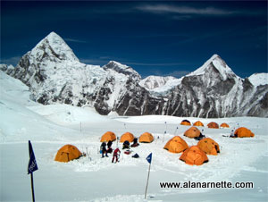 Climbers still cannot actually see Everest until they go another quarter mile up the Western Cwm, they do have a spectacular view of Pumori and other 7000m hills behind them. I have already described climbing the IceFall so here is a description of the last steps to Camp 1.
 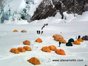 There are normally five to 8 ladders in this area along with a fixed rope. Climbers are told to always attach themselves to the rope and be extra careful in this area. There is a tendency to relax their guard but now is not the time.
 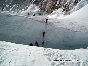 It is about 1.74 miles from Camp 1 to Camp 2 with an altitude gain of 1,500'. So it is not far and not that high but ... it is hot, very hot if they travel in mid day. So most leave Camp 1 at 6:00 AM or earlier.
 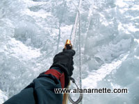 Climbing the Lhotse Face is a big challenge after the Khumbu Ice Fall on the way to the summit. There are usually two ropes, an up and a down, attached to the face with ice screws and anchors.
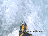 Depending on the weather, the Face is usually rock hard blue ice. Climbers have to kick their crampon points into the ice stealing precious strength with each step. After a few weeks, the path is fairly well set due to the thousands of kicks into the ice but one storm can have climbers starting all over again.
 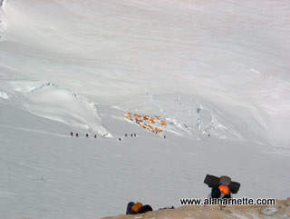 Let's take a look at the climb above C3 and onto the South Col. The terrain starts out fairly steep from C3. Most climbers are on supplemental oxygen and leave their tents after sunrise.
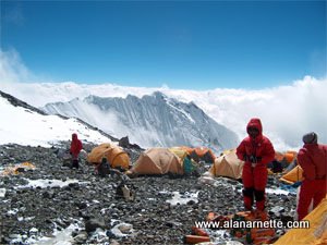 defining the South Col. This is actually on the Geneva Spur.