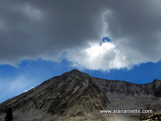
Snowmass Mountain
Colorado 14er
14,092
Colorado 14er
14,092
|
|
Snowmass Mountain Colorado 14er 14,092 |
|||||||
|
||||||||
 Some mountains you enjoy going up, others coming down but in my experience, rarely both - Snowmass was no different! Located in the Elk range just west of Aspen, Snowmass is known primarily for it's permanent snowfield (thus the name) and being very remote. Not many people see it since it is only visible from high up on nearby 14ers. Click on any picture to enlarge it. The normal route is from the east and is a 21 mile round trip that most people backpack in, climb and pack out. The alternative is the West Slope route which requires a 4WD to reach the trailhead on an 8 mile narrow and rough dirt road outside of the town of Marble, Colorado. This was my plan for this early September 2009 climb. 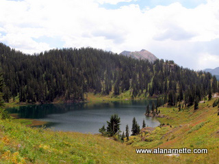
The trailhead, at 9710', is almost at the end of the road in Lead King Basin. I arrived around 6:00PM and found a beautifully flat campsite near the trailhead carpeted with pine needles - beside a running stream - perfect! As I set up my tent I met a couple, John and Valerie, camping nearby who were taking the S Ridge to the summit. I was going for one of the West Slope gullies which involved a 2,000' scree climb - not my favorite! So I asked, and they kindly agreed, to let me tag along on the S Ridge since I had not researched it at all. We left the trailhead at 4:00 AM with headlamps lighting the well marked trail through open meadows and closed pine forests to Geneva Lake. It only took 45 minutes to get there. The S Ridge is not a highly popular route so we only had a few pictures from a trip report to serve as a guide. And since we had made good time to the base of the ridge, it was still dark - not the best scenario to start a potential class 4 climb. So we waited for the early rays of sunrise, spotted the correct gully and started the climb. 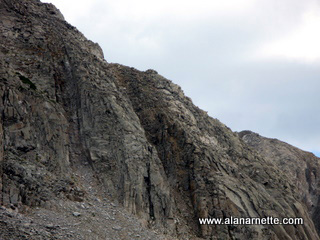
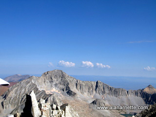
Leaving the Geneva Lake area at about 11,500 we climbed what looked to be a steep rock gully on the far south side of the ridge. Up close it was a moderate climb but filled with loose rocks - a harbinger of things to come on Snowmass' west slope. We reached the ridge proper at 12,500 and started our traverse to the summit. 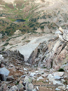 The route finding was somewhat straightforward with John spending most of the time out front and Valerie and I spotting features from behind. The climbing was fun - this was climbing, not hiking a 14er. However it was also a tad dangerous. While most of the time was solid class 3 with firm footing and good handholds, occasionally we found ourselves on class 4 terrain with extreme exposure. But by staying on the west side of the ridge we made steady progress towards the summit. As we climbed higher, the normal route came into view to the east. it appeared shorter than our beloved S Ridge. It took us 5.5 hours from tents to summit including a wait for daylight and we summited around 9:30 AM on a clear day in the Elk Range. We visited with climbers from the normal route, took the obligatory pictures and videos. I studied nearby Capital closely since my plan was to climb it the next day. The knife edge was in clear view as was the feature named K2 on the ridge approach. 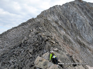
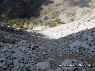
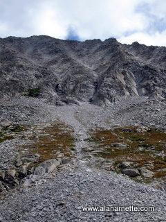
The descent proved to be not as fun as the ascent was fun. The target gully mostly mentioned on West Slope climbs of Snowmass was a few minutes from the summit. As I looked down all I saw was loose rock - not only annoying scree but also rather large rocks that could easily roll onto a foot or ankle. We started the descent. I took it very slow as my younger couple made faster progress towards the basin below. 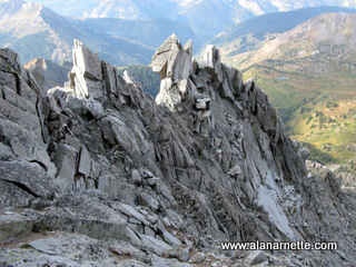
While not technically difficult, the loose rock was slow going and being at an angle anywhere from 10 to 30 degrees, quite steep at times. A couple of loose rocks tumbled below me as I yelled out "rock" and then "clear; sorry" to my new partners. Along the way, my worn out knee took a twist which slowed me further but after 2 hours, I was down and headed back to camp. So 14er number 48 is now in the books. I have mixed feelings about the climb. The route to take on the west is absolutely the S Ridge - no doubt. Climbing up the scree gully would be tedious at best, annoying at worse but doable. 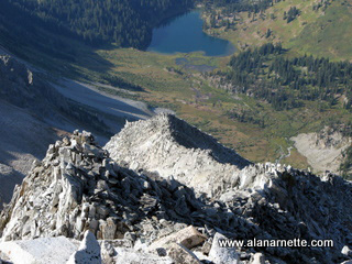
However, one variation would be to climb the scree up and take the ridge down. But in any event, the S Ridge is what makes it all worthwhile. But there was a price I paid. My twisted knee stopped my plan to climb Capital the next day. Beautiful views, challenge rock at times and the satisfaction of a summit not by the normal route. Thanks to my new friends for letting me tag along - it was great day.
  I returned to climb Snowmass from the traditional East Slope side. Highly recommended! |
|